There is a love of technology that some human beings possess, a love of technology for its own sake. I will confide in you. I am that person. I am drawn to glittering new tools, devices, and software like a moth to flame. Occasionally, we technophiles can be burned by badly designed, unfriendly – or worse – useless technology that generates more pain than pleasure. GIS, or Geographic Information Systems, is not one of those. It is a thing of beauty and wonder; it has the ability to reinvent one’s understanding of the world around us, whether that world is natural, manmade, or social. As an example of the social world, natural disasters generate thousands of Twitter tweets that each contain embedded location information. The tweet locations can be mapped and their spatial pattern might be used to estimate the initial extent of the disaster. A sound application of GIS concepts and tools can explain, can communicate, can enlighten, and can even predict the world around us.
All Things Spatial
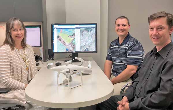
I am the GeoServices Manager for your Aiken County Government. In that capacity, I manage the creation, care, and analysis of all things “spatial” for the County, including web mapping, parcel boundaries, road centerlines, zoning, city limits, zip codes, U.S. Census projects, 9-1-1 addresses, and 9-1-1 emergency response boundaries for law, fire, and EMS, to name just a few. I have “done GIS” for Aiken County for almost 11 years, and I supervise a talented staff of six GIS professionals serving the citizens of this county.
Before coming to Aiken County, I held a similar position for The Nature Conservancy in Colorado. Before that, I earned a Masters in Plant Biology from Arizona State University, where I learned my spatial craft. I am passionate about the value of spatial analysis and spatial thinking, and my goal is to impart to you a sense of GIS as a widespread technology and as a way of thinking. I work in close cooperation with gifted local government colleagues at the City of Aiken and the City of North Augusta, who are my kindred GIS spirits. Together, we are working to create a world-class spatial infrastructure to benefit all the citizens of Aiken County. We are achieving that by developing a comprehensive, linked database of location-enabled data and the analyses and applications needed to make good use of those data.
Maps and Mapping
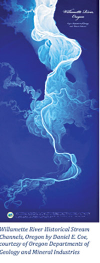
Handcrafted maps have been used by human beings for thousands of years. Many of them have been preserved for their historical value and beauty, and map lovers will enjoy browsing the archives available on the Internet. One such archive is the South Caroliniana Library collection of Sanborn Fire Insurance Maps. This library is part of USC; its online address is https://digital.library.sc.edu/collections/sanborn-fire-insurance-maps-of-south-carolina/. Another good source is Stanford’s David Rumsey Map Collection at https://www.davidrumsey.com/. Finally, old map lovers should also try Old Maps Online at https://www.oldmapsonline.org/.
Computerized mapping with GIS is much younger. It was born in the academic world more than 50 years ago and is now a basic tool for every sector of human activity. It is widely used to great advantage in government, academia, business, nonprofit, and even personal applications. GIS is a tool once used by the few and today used by many. Tomorrow, I predict, it will be as common as any spreadsheet or word processing software, and every computer user will be able to use GIS as a matter of course, without hesitation. We are rushing toward this new status quo faster than you might imagine, so prepare yourself to join the fun.
The Where
I define the term Geographic Information System as a partnering of specialized software and data used for the purpose of understanding the space and time patterns of our location-centric world. I invite you to ponder this. Almost every aspect of human activity occurs somewhere. That where is the location, and is the main focus of GIS analysis. Immediately, it should become clear that many of your questions and problems can benefit from the GIS toolkit. Just as you can easily see how a word processing application such as Microsoft Word or an email application like Gmail is useful throughout your day, perhaps you will now begin to envision ways in which the problem at hand is location-dependent. GIS analyses can give you insights and solutions that previously might have been unrecognized.
There are three basic roles of a good GIS. Its most well-known function is the creation of maps. Maps are so widely used that many people think of that and nothing else when they think of GIS. A map can be a beautiful and effective way to share location knowledge with others. It can also be a fabulous communication tool for describing complicated relationships. Many professionals produce maps that are nothing short of art in their own right. A map that is both beautiful and understandable is a worthy goal for all users of GIS. However, it is a mistake to think of GIS only in terms of the maps that can be made and shared. This is a key misconception and disregards two other major benefits of GIS.
The What and How
GIS is a powerful and intuitive method of organizing and storing data. A good GIS database is the starting point for new information. Location is a very useful way of sorting and storing the many (seemingly) unrelated details or facts about the world. Almost every fact that a human can discover or document has a location. A GIS database stores those facts like any other database; it is different in that it also stores the location of that fact which makes it enormously useful and adds meaning. Here is an example. Elevation above sea level, in its most basic form, is a number and a unit such as 5280 feet. That number becomes more meaningful when you consider the locations of that particular elevation. So, the 13th step of one particular State Capitol building in the United States is 5280 feet above sea level and that step’s location can be described as 39.7392 degrees latitude north, 104.9848 degrees longitude west. I am referring, of course, to the State Capitol building in Denver, Colorado!
Another major benefit of GIS is its ability to help you analyze many facts in relationship to their locations and learn brand new things (i.e., discover new facts) or solve complicated problems. There are an infinite number of facts that relate to any given location: its average annual rainfall, its city zoning classification, its distance from the Sun, its census block number, how many trumpet players reside within one mile, the exact distance from that location to another location with the same fact, and the list goes on.
GIS software contains tools that facilitate a multitude of interesting analyses, either of many facts at one location or of many locations with one fact. The hundreds of tools provided by GIS software each provide a different analysis and they can be combined like beads on a string in an original way to answer a more complicated question. New insights will be gained and will be communicated to other people by the usual charts and graphs, tables and paragraphs, or by beautiful maps which are often understood more easily than a graph or a table. The location component is key to both the analysis and the map.
Local Applications and Advances
As I mentioned earlier, Aiken County, City of Aiken, and City of North Augusta are creating a robust database and powerful tools to make use of it. So what?
The full list of all the government uses of GIS that impact the daily lives of citizens would be long and tedious. It is enough to say that many local government decisions and services benefit in some way, large or small, from the use of GIS, even if its role is often hidden.
My colleagues and I are always working to expand GIS benefits, making good use of the investment and resources. Here are some examples of recent GIS work in local government.
NG911
Aiken County, the City of Aiken, and the City of North Augusta have been working together since 2017 on a project to upgrade our existing Enhanced 9-1-1 system (E911) to Next Generation 9-1-1 (NG911). The upgrade is planned for later this year.
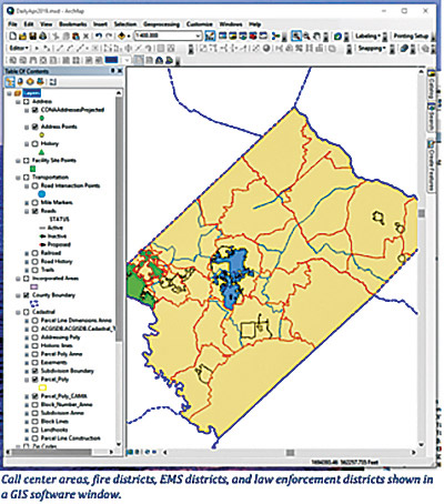
NG911 changes the underlying infrastructure of the 9-1-1 system from analog to digital, which is necessary to provide the cutting-edge 9-1-1 services expected by modern users. It does not provide those services but rather serves as the transport backbone on which they will be based. This digital backbone will provide faster, more reliable, more accurate transport of 9-1-1 calls to the local dispatch centers. This upgrade is a necessary first step to allow for future 9-1-1 software features such as texting with callers, receiving video from callers, and many other long-term upgrades.
GIS data has always served a purpose in routing and dispatching 9-1-1 but it will play a much larger, more essential role in the operation of the new NG911. GIS data will be the basis upon which 9-1-1 calls are verified, are located, and are routed by the telephone carrier to the correct dispatch center. It will also provide information used by the 9-1-1 dispatcher to determine which responding agencies are sent to the scene.
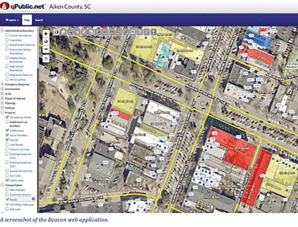
BEACON
In 2016, working with a third party vendor, the County developed a comprehensive GIS web map for citizen use as a reference tool. Called “Beacon,” or by its former name “qPublic,” this tool combines the most current County GIS data with current County Assessor data to provide a one-stop resource for property, zoning, addresses, and many other categories of information. The data is updated daily and it offers a large number of tools used to select properties of interest, download their data in spreadsheet form, or make custom maps for private use. This web application can be found on the County website at www.aikencountysc.gov.
WORKFORCE
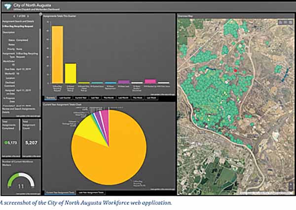
The City of North Augusta has created an online map application called “Workforce” that improves the efficiency of sending out city workers to perform service requests from citizens. The city’s service dispatcher and management (for utilities, sanitation, etc.) use the application to communicate assignments to work crews and manage their progress. The city work crews use the application from their smart device in the field to note the progress of the work and any comments they may have. This application has saved the City of North Augusta a significant amount of time and money and has earned the City a national GIS award which will be presented at the upcoming Esri International Users Conference in San Diego, California.
REAL WORLD MODELING
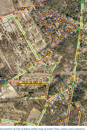
The City of Aiken uses GIS in many different ways to make more informed decisions. By using GIS to model real world situations, the City can predetermine the effects of a given decision. In this example, the City’s Engineering and Utilities department uses GIS to see how many customers would be affected by a water shut-off during a planned water line project. The yellow lines indicate which water lines would be affected and in turn, which homes and businesses associated with those lines would be affected. It also shows the result of closing different water valves in the system in order to minimize the impact to citizens. Advance planning of this nature helps local governments reduce cost and inconvenience for necessary maintenance activities.
As GIS technology develops, it is moving in the direction of targeting nonprofessional users. You already use GIS every time you use Google Maps, Bing Maps, etc. The goals of GIS software companies are to make it easier to use and to make it accessible from the web rather than solely through expensive, complicated desktop software. As this trend continues, you may find opportunities to download apps that add easy spatial analysis abilities to your personal computers and devices. I encourage you to take that leap. My colleagues and I will also be introducing new and glittery web mapping products that we hope you will find easy, useful, and fun. Keep an eye on our official websites for future enhancements: www.aikencountysc.gov, www.cityofaikensc.gov, and www.northaugusta.net.
by Cherie Moritz, Guest Writer